


These Loops Were Made for Walkin’: 8 Walking Trails with Wonderful Views
The Eureka Springs area is a mecca for hikers, and everyone knows you can do some hardcore hoofing around here. But not every trail is steep, curved and rugged; some are just right for a leisurely stroll, with stops along the way to behold the natural scenery. (Of course, feel free to pick up the pace and get your heart rate up.)
In this article, we’ll introduce you to some picturesque trails that are rated easy to moderate, and appropriate for all skill and endurance levels. And while these routes may be rated as “easy,” they’re not tame. None are paved. This is, after all, the Ozark region in Arkansas, the Natural State. Click on the links and they’ll take you to AllTrails, where you can view a trail map and its proximity to downtown Eureka Springs.
Black Bass Lake Trail
At 1.8 miles long and a little over a mile from Historic Downtown, Black Bass Lake Trail is ideal for visitors looking to get going with some fresh air and lovely views. The trail is fairly level (only 140 feet in elevation gain) and mostly hugs the lake shoreline, although a spur leads you up and along a bluff. You’ll pass plenty of rock formations and gurgling streams. A stone dam that dates back to 1894 is close to the small parking area and information kiosk. Enjoy the quiet — there’s no traffic noise.
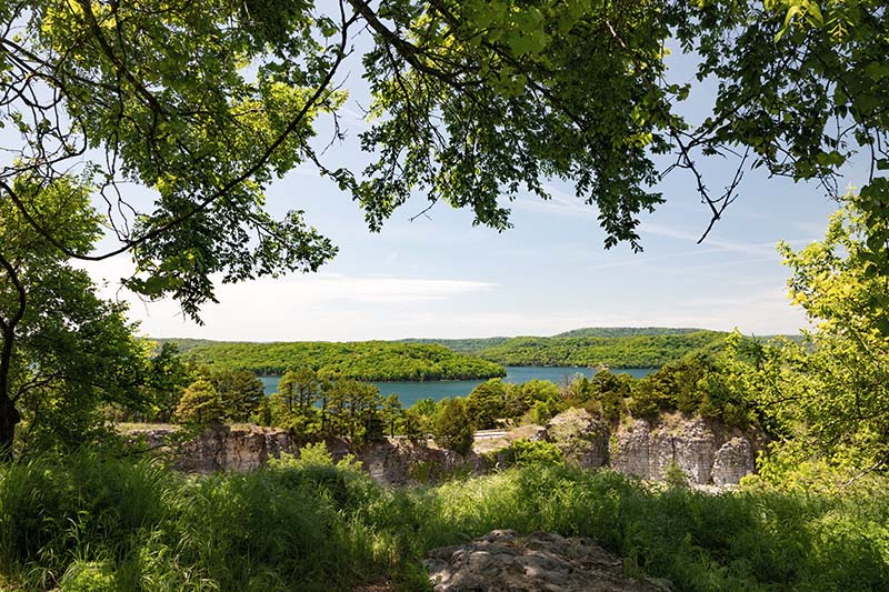
Lake Leatherwood Loop
Perfect for leisure hikers who want to take in the sights and sounds of a gorgeous park, this trail is mostly flat and loops around the full length of the long, narrow 85-acre lake. Lake Leatherwood is home to one of the largest hand-cut limestone dams in the country, and the trail passes the quarry that the rock was mined from. A long walking bridge traverses the lake, offering even more stunning views. The Loop is 4.2 miles, but it connects with a vast network of other trails in the park, some of which offer more challenging treks. Keep an eye out for wildflowers, which are plentiful depending on the season. Lake Leatherwood City Park is five miles north of downtown.
Hyde Hollow Trail
Another Lake Leatherwood offering, the two-mile Hyde Hollow Trail runs south of the lake along wide expanses of green grass, through forest, over a wooden bridge and across a tributary creek six times. It’s best to avoid this trail in times of high water, as it can be impassable. In the right conditions, though, the route is gorgeous.
Eureka Springs Overlook Loop
Also located in Lake Leatherwood Park, this 2.7-mile course on the west side of the lake has 350 feet in elevation gain and includes an array of sharp turns. This loop includes plenty of rock formations, including stone arch bridges. It has a few challenging inclines, and is rated moderate. Keep an eye out for colorful wildflowers, when in season. The trail leads to a bluff overlooking Leatherwood Dam, best seen when there are no leaves on the trees.
Dogwood Overlook Trail
This two-mile trek is located on the eastern side of Beaver Lake, a go-to place for outdoor recreation about 30 miles west of downtown. The trail is rated as moderate and contains some fairly steep climbs. The trailhead is at the Beaver Dam overlook, so the breathtaking views start right away. The loop features spectacular geographic features, including one of the largest rock overhangs in the area. Keep an eye out for dogwoods in bloom throughout April and May.
Kings River Overlook Trail
From downtown, head about 20 miles south to the eastern edge of the McllRoy State Game Management Area, where you’ll find this 1.2-mile walk along the steep bluffs of the winding Kings River. You’ll be treated to sensational vistas of the river and a wide-angle view of the Ozarks — which, during the fall, is a sea of colored leaves. Look for small waterfalls, caves and flowers. Those moving specs on the river are most likely kayakers. This is a wide, out-and-back trail, so the full course runs 2.4 miles.
Poker Bluff Trail
Seven miles north of downtown you’ll find the small town of Beaver, Arkansas (pop. 100) on the banks of the White River. The out-and-back Poker Bluff Trail, the easiest hike of the ones covered here, runs west for .6 miles. It also provides terrific up-close views of the river, as well as the historic Beaver Bridge, the only suspension bridge open to vehicle traffic in Arkansas. The mostly flat trail runs along an old railroad grade, with the tracks removed. You’ll also see a small waterfall or two.
Starlite North Trail
If you like easy-access trails that feel like they’re deep in the wilderness, this one’s the ticket. Located about nine miles north of downtown, the 1.3 mile Starlite North loop winds through heavily wooded terrain, with wildflowers bordering the path. Now and again, the forest gives way to panoramic views of the Ozarks. The trail can be accessed off of Starlite Avenue just south of Holiday Island Community Church.
Happy trails!

From The Blog


